GeoTag-X is a humanitarian project developed by UNITAR/UNOSAT as part of the Citizen Cyberlab project. Built on Pybossa, this open source project is designed for volunteers to assist humanitarian disaster responses.
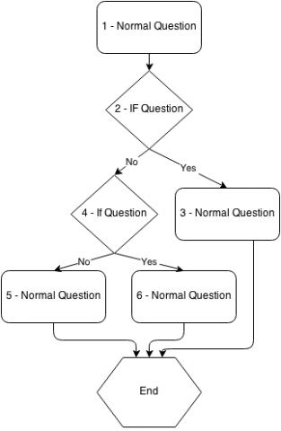
At the moment we have a limited structure of questions to analyse information about images. This idea is about developing a diagram structure for the order in which questions about photos will be designed - in what order and under what conditions. This idea complements our idea for a user-friendly interface for new modules, but this one is about designing the structure or decision tree for modules rather than a drag-and-drop user interface.
At the moment, new modules are coded from scratch in JavaScript and HTML or adapted from existing code. As GeoTag-X grows and more modules for different projects are created, it will be easier if formats for the orders of questions were standardized and offered as templates depending on what infomation is being sought.
Rather than developers coding each new module, eventually we hope NGOs with different needs will be able to plan modules based on the decision tree, which can help guide them on logical orders of questions.
- decision tree for geotagx modules
- new participants in the geotagx.org volunteer community
- user interface design
- logic
Prerequisites:
none